
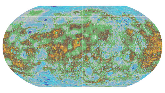
NASA’s MESSENGER mission has published the first complete topographical map of the planet Mercury. To be precise, it’s a Digital Elevation Model (DEM), a representation of the elevation distribution of territory, or of another surface, in digital format. It’s the product of the processing of data collected by the MESSENGER space probe during its mission ended just over a year ago.
This topographic map is the result of the collaboration with U.S. Geological Survey, Arizona State University, Carnegie Institute of Washington, Johns Hopkins University Applied Physics Laboratory. Previous Mercury topographical models were created in the past, again using measurements of the MESSENGER (MErcury Surface, Space ENvironment, GEochemistry and Ranging) space probe, but the new one is much more accurate.
Over 100,000 images taken by the MESSENGER space probe were used to create the new model. It allowed to reveal a number of new topographic features that include Mercury’s highest and lowest points. The highest elevation was found to be 4.48 kilometers (2.78 miles) above the planet’s average, the lowest is 5.38 kilometers (3.34 miles) below the average, in Rachmaninoff basin.
An area of Mercury that was known with limited accuracy was the one near the north pole. There, the Sun is always low on the horizon, creating long shadows that can obscure the rocks’ colors. For this reason, the Mercury Dual Imaging System (MDIS) instrument was used to take images of the area when the shadows were minimized using five different color filters.
The management of images taken from different positions and distances of the space probe is always a problem, also because one of the consequences is the different position relative to the Sun and therefore images with different levels of brightness and shade. The U.S. Geological Survey Astrogeology team used a software technique to create homogeneous maps starting from images taken under different conditions.
The MESSENGER space probe accomplished its mission even better than expected thanks to a couple of extensions. This success allowed to greatly increase our knowledge of the planet Mercury: it may seem just a dead planet burned by the Sun but also for that reason the information collected about it will help us better understand the history of the inner solar system and therefore also of the Earth.
NASA also created a clip that shows Mercury’s topography.
